Welcome to a guide of Exactix’s mapping tools! Mapping plays a vital role in the SC811’s locate notice process. Keep reading to learn when to use each tool, the importance of the map buffers, and how Exactix uses the mapping in conjunction with the service areas provided by our Member Operators to determine who to notify of each request. Have some ideas of improvement or topics that could be explored? We want to hear from you! https://sc811.com/dig-or-drag/
What marking tools are used in Exactix?
Exactix is the software system SC811 uses to obtain the necessary information to ensure the work
site or general location is accurately located on the map.
Exactix will highlight the area based on the information the user provides in the site information
section of the ticket. In some instances, the system may be unable to locate an area or accurately
map a dig site, and the user may need to select a mapping tool and manually highlight the area.
Each mapping tool uses a set buffer zone size. The buffer does not indicate the area needing to be
located, nor does the mapping replace the need for detailed marking instructions on the locate
notice.
Below is a list of the available tools and when to use each one.
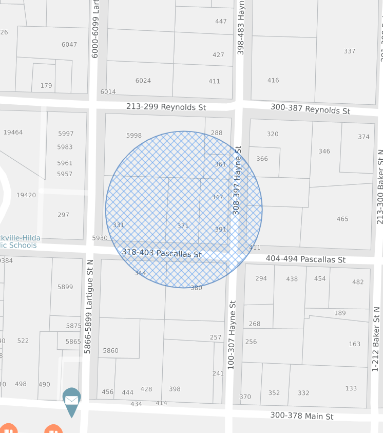
Draw Circle: The draw circle tool marks an intersection
or
single-point address if the property lines fit in the coverage radius.
PROPERTY ADDRESS
Draw Line: The draw line tool is used when requesting
markings
on roads, right of ways, railroad tracks, or easements.
timeline
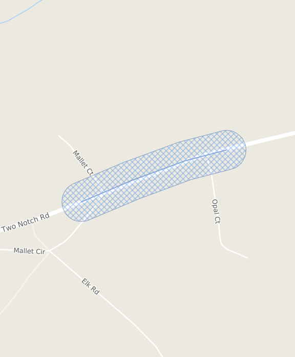
ROADWAY
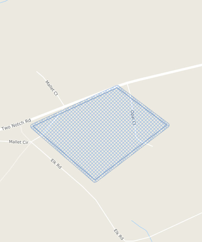
Draw Polygon: The draw polygon tool is used to mark
large
work
sites that the draw circle tool does not cover and for marking multiple side-by-side
properties.
DRAW POLYGON
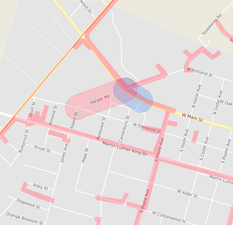
Service Areas
Exactix allows Member Operators to provide files or draw their service area on the map. These areas indicate places where underground lines may be present, and the Member Operator needs to be notified of plans for excavation. Service areas appear in solid “pink” on the map. The image below shows the mapped area and the buffer extending to pick up the service area.
When and Why Manual Mapping is Required?
Exactix will attempt to choose the correct mapping tool and highlight the area based on the
information input by the user.
In some instances, the user may need to manually map the area.
Reasons for manually mapping include but are not limited to: new addresses, new subdivisions, work
taking place along partial roadways, easements, right of ways, multiple addresses, or when the
system fails to find or adequately highlight the area.
SYSTEM MAPPING
AND
MANUAL MAPPING
SYSTEM MAPPING
AND
MANUAL MAPPING
ADDRESS POINT: Exactix automatically finds and maps the address using the correct mapping tool. These are single property addresses marked on the map with a draw circle.
PARCEL: The address is a large parcel and the circle tool was not sufficient to cover the property boundaries. Exactix automatically mapped the area using a polygon that fits the shape of the parcel.
**The difference between an address point and a parcel is the shape/size of the address and which tool best fit and covered the property**
INTERSECTION: The Dig Site Type in the Site Information section of Exactix is changed from Street/Address to Intersection. Exactix finds and maps the intersection from the information put in the system. Exactix highlights the indicated intersection with a draw circle.
MANUAL MAPPINGMANUAL: The user chose the mapping tool to map the area. subdivisions, work along partial roadways, easements, right of ways, multiple addresses, or instances where the system fails to find or adequately highlight the area.
The labels and percentages in the pie chart depict how Exactix records the way the area was mapped in the system.
If Exactix can find the area, it will automatically map it. If not, the user must manually map the site using the correct mapping tool.
Using the correct mapping tool is extremely important to ensure the property boundaries are covered, and all of the necessary Member Operators are notified.
How does a site marker within Exactix work?
To better understand how the mapping tools work and how the buffers are used to pick up nearby service areas and notify Member Operators, Try the interactive map below. Click anywhere on the map for instructions on how to use. For more information or training on how to process locate requests online and map dig sites using Exactix, please visit our online training library.